Computer vision
Identify defined objects and conditions across satellite, aircraft, drone, street-level and site imagery.
Feature extraction
Object detection
Condition classification
GEO AI & machine learning
GEOVIZ combines spatial context, AI models and expert verification to transform imagery and sensor data into transparent, prioritized decisions.
Not only geospatial
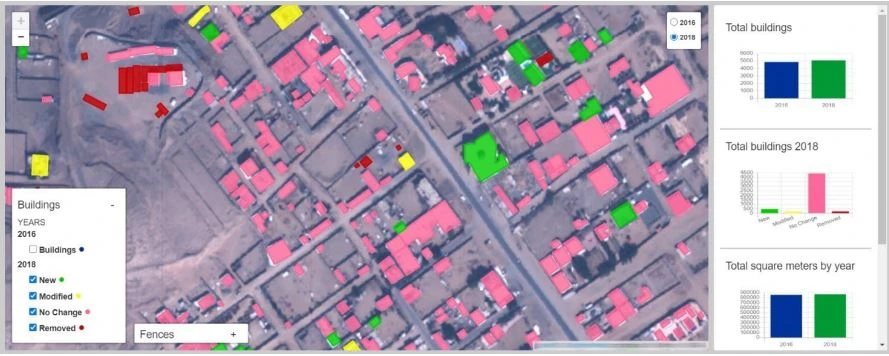
Traditional geospatial systems show where things are. GEOVIZ adds an intelligence layer that detects patterns, understands change, documents confidence and helps teams decide where to act first.
Identify defined objects and conditions across satellite, aircraft, drone, street-level and site imagery.
Compare places across time and distinguish material change from background noise.
Train and refine models around the client’s operating context, evidence and decision rules.
Move verified findings into dashboards, alerts and workflows where teams can act.
One GEO AI loop
Continuously collect evidence from satellites, aircraft, DJI Dock, drones and ground systems.
Apply models trained for the defined feature, condition or change class.
Keep confidence, traceability and expert review visible before operational use.
Send prioritized findings into dashboards, alerts and accountable workflows.
GEO AI applications
Buildings, plots, visual pollution, compliance and development change.
Assets, corridors, defects, encroachment and priority maintenance.
Progress, quantities, deviation, safety conditions and interfaces.
Vegetation, habitat, coastline, land condition and material change.
Responsible by design
Every operational output should remain linked to source imagery, spatial location, model confidence and the expert review that supports the final recommendation.
Your project
We will identify the spatial evidence required to support it.